The information in these pages has been drawn from a wide range of sources. Particular thanks go to Robert Bosworth for much of the history of Warmington and Bob Daniels who has a large repository of data on the village. We have also received a message from Michael Cole of York who is researching our village history and has some questions - can anyone help?
We always welcome further information on the history of our village to keep our general interest section up to date. If you know anything that could help that we do not currently have covered please Contact Us.
Eric Heath, who lives in Warmington, has written a small book about local football including the Warmington Wasps For more information go to www.yourgrandadsfootball.co.uk which has a large collection of information and photos of local football teams.
The history pages are subdivided into the following sections:
- Before 425 - Pre-Settlement Times
- 425 to 865 - The birth of Warmington
- 856 to 1066 - The coming of the Danes
- 1066 to 1300 - The Norman invasion
- 1300 to 1393 - Famines and the Black Death
- 1393 to 1746 - Expansion and enclosure
- 1775 to 1874 - The start of the Proby era
- 1875 to the 21st century
Before 425 - Pre-settlement times
The place we have called Warmington for about fourteen hundred years has probably been occupied for over 3,000 years. Evidence of early occupation, even if it was only transient in nature, is quite common in the area. The archaeological investigations carried out prior to the building of the by-pass in 1996 provided a wealth of information and several very important finds. These combined with previous finds and investigations, suggest there were Bronze Age, Iron Age and Roman settlements in the immediate vicinity.
 Among the earliest finds are two bronze palstaves (a form of chisel) found in the churchyard and, perhaps the most important, a Beaker Burial discovered near to Mill House where the new road runs down passed the new Elton Boat Club House to the Mill. The body dates from around 1,000 BC and was buried with a flint knife, several arrowheads, jet buttons and an ornate pottery beaker. These burials are not uncommon and have also been found in other villages along the Nene Valley.
Five ring ditches, several series of liner ditches and a number of settlements have been located around the village including a large complex that straddles the A605 in the area where the new by-pass starts at the north of the village.
Most of the features were revealed as crop marks and recorded in aerial photographs of the area. Finds made within the complex include a flint axe and other flint tools. The complex is bisected by the line of the Roman Road that ran from Irchester to Water Newton.
Evidence of Roman settlements have been found in three locations around the village. West of Warmington finds of Roman pottery, roof tiles, coins and oyster shells were made in 1962. To the south near the parish boundary with Tansor, Roman finds of pottery, tiles and stone rubble have been made. Near to the deserted village of Papley, Roman finds have included, pottery, tiles, limestone rubble and two pieces of fire-bars probably from a kiln.
425 to 865 - The birth of Warmington
We know very little about events in England during the 250 years after the departure of the Roman legions in the first quarter of the 5th Century. The dark ages continued until 597 when the conversion of the English to Christianity begun and continued throughout the 7th Century. However, we do known that during this period the foundations were laid for the pattern of English villages and hamlets that, for the most part, survive to this day. Warmington was just one of the many settlements to begin during this period.
 From about 450 onwards raiding and settling parties of people now generally referred to as Anglo Saxons began to penetrate up the rivers of the eastern seaboard of England, notably through the Thames estuary, the Wash and the Humber.
They were a race of valley dwelling warrior farmers whose first settlements were made either on occupied land, which they overran or on previously tilled land found already deserted.
These early settlements were based on family groups led by a headman. Where this subsistence farming was successful the group might outgrow the land and a breakaway community would be formed. Many of these secondary settlements date from between c.550 and c.800. It was common for the leader of the group to give his name to the settlement and so this village became the tun of Wyrma's people, which through various changes became Warmington.
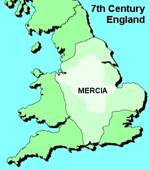
The village appears to have been in existence by the time Medehamstede (Peterborough) Abbey was founded in 655. The lands being granted to the Abbey by Wulphere, King of Mercia.
It would have been during these early years that the first cultivation field was opened to the west of the village. The houses and barns of wood and thatch would probably have been centred round the site of the present church. Over the next 200 years or so saw a gradual expansion of land under the plough and at some point a second open field was created to the north of the village.
This enabled the original Westfield and the new Bolwellfield to be cropped for one year and lie fallow for one year in turn. Inroads were also made into the great forest of Bruneswald that covered the heavy clay land to the east of the village across the higher ground. Also Papley, whose Anglo Saxon name means Pappa's clearing, may date from this period, either late 8th or early 9th century.
856 to 1066 - The coming of the Danes
 From 865 onwards the Danish raids began and in 870 the heathen Danes completely destroyed Medhamstede Abbey, killing the abbot and monks. It may be assumed that as the village came under the Danelaw and any wooden church that might have stood here would have been destroyed.
Despite the ferocity of the initial onslaught, there seems to have been no major displacement of populations anywhere in Northamptonshire and Danish farmers settled alongside the English. They made no attempt to change the agricultural system that had now been in existence for two centuries.
In 886, Alfred and Guthrum negotiated a treaty between Wessex and East Anglia to help prevent quarrels between the Danes and the Saxons that could lead to war. One important clause laid down the southern boundary commonly recognised as that of Danelaw.
Over the course of about 100 years the Danes were gradually forced back northwards and the Danelaw became absorbed by the English. The Danes swore allegiance to King Edgar who is considered to be the first true King of England. Under Edgar, Medehamsted Abbey was rebuilt and the lands of Warmington returned to the control of the abbot, where they remained for nearly 600 years.
The Danish invasion had given a new impetus to agriculture and the economy. There was also growth in the number of settlements in the country.
It is probably during the Danish period that Eaglethorpe was established. "Thorpe" is Scandinavian in origin, meaning a subsidiary settlement or farm, although the name continued to be used by the English long after the Danish period.
The "eagle" part of the word may be derived from the ancient Scandinavian "Eik" or Ekel" meaning Oakwood. Thus Eaglethorpe could have been the settlement by the Oakwood.
Whilst the location of Papley village is well known and documented, the site of Eaglethorpe has not been positively identified. The road that now bears the name Eaglethorpe originally formed part of Mill Way Street in 1600 and was known as Mill End until official road names were given in the late 1950s, when it became Eaglesthorpe. The hamlet of Eaglethorpe was probably further to the north of the parish, maybe as far north as the boundary with Elton.
1066 to 1300 - The Norman invasion
 The Norman invasion of 1066 saw the greatest upheaval in England since the Danish attack 200 years earlier. The old Anglo Saxon feudal lords were swept away and their manors given to the Norman barons, knights and churchmen who had helped give William the victory. Eventually a Norman abbot was appointed at Peterborough and was made responsible for the provision of 60 knights both for the protection of the Abbey and to fight in the King's army when required.
This measure led to the introduction of the Knight's Fee whereby the knight would receive an allocation of land from the Abbey in return for his military service. Many of these knights fees appear in the Domesday Survey completed in 1086. It was compiled not as a sort of census, but more as a register of land and property on which taxes might be levied.
The Warmington entry in the Domesday Book may contain errors; indeed in the translation of the Northamptonshire section the general editor states there are numerous mistakes throughout the county and feels it is not so carefully compiled as many other regions.
Whether error or not it seems highly unlikely that the bulk of Warmington lands would be in Polebrook Hundred, when a glance at the Hundred map shows Warmington to be wholly in Willybrook Hundred as indeed are Lutton, Tansor and Elmington, all of which are nearer to the boundary with Polebrook Hundred.
The parcel of land shown to be held at a knight's fee by 2 men at arms in Willybrook may refer to Eaglethorpe whilst the land held by Isembard and Rozelin was probably Papley.
The survey shows a total of 10 hides, approximately 1200 acres, of arable land, the vast majority held in demesne, i.e. by the abbey. Though during the 12th century there were more grants of land to various individuals by the abbot, all held at a full or part knight's fee. This may have come out of the Abbey's existing lands or it may have been due to the creation of a third open field.
The two hundred years of so following the Domesday survey saw a tremendous growth in the population of the country. By 1300 it has been estimated that the population of Northamptonshire had grown to about 104,000 from a Domesday figure of around 30,000 - an amazing increase. Increased wealth, especially among those with the largest holdings of land, saw the building and endowment of the village church, and also the development of Southorpe, along the line of what we know as Taylors Green, and stretching on both sides of the street along nearly its entire length.
It should be borne in mind that the agriculturists of this period had no fertilisers or manure for spreading, but rather relied on turning their animals out on the open fields during their fallow period and then ploughing in such manure as there was at the end of that period.
1300 to 1393 - Famines and the Black Death
The dramatic increases in population saw fields being over-cropped and eventually the land became starved and decline set. During the 14th century there were many harvest failures and famines and this in turn exposed the population to various diseases, by far the most serious of which was the bubonic plague the Black Death.
 To find the arrival of the Black Death in any village, perhaps the most reliable way in the absence of any documentary evidence is the "Vicars Test". An examination of Warmington's list shows that there were 3 vicars in 1349/50 and so it is fairly certain that this pinpoints the first outbreak here.
It has been estimated that the population of the region had fallen by 40% following this first outbreak of the plague, but there were four further outbreaks before the end of the century and these seem to have severely affected the younger adults and children.
All this led to the desertion of some villages, but Warmington survived though with a population that may have declined by as much as 60% and it is from this period that the gradual decline of Southorpe, and probably also Eaglethorpe, began.
It did, however, bring about the virtual collapse of the feudal system since labour shortages enabled peasant farmers and cottagers to convert feudal dues to money payments and to obtain leaseholds on their properties, and the period following the last major outbreak of the plague in c.1390 became a good time for these smaller landholders.
Following the last visitation of the plague, the arable land at Warmington was, in 1393, turned over to four open fields, Westfield, Bolwellfield, Ernefield and Blackthornfield. This may appear somewhat strange given the fall in population, but was probably done in an attempt to improve cropping and to allow for longer fallow periods.
1393 to 1746 - Expansion and enclosure
The gradual decline of Southorpe and Eaglesthorpe was not matched by Papley, which in 1517 drew the unfavourable attention of the King's Enclosure Commission. In 1456 Richard of Papley sold his lands at Papley to William Brown, a Stamford merchant. He died in 1490 and was succeeded by his daughter Margaret whose own daughter married John Elmes.
In 1499 Elmes enclosed 200 acres of land and turned it over to sheep pastures. Seven houses were destroyed. A court case ensued at Star Chamber in 1539 when fines were imposed but the damage had long since been done and Papley had practically become a deserted hamlet. Following the reformation of the Church by Henry VlIl the dissolution of the monasteries was set in train. In 1535 Thomas Cromwell's commissioners visited the county and within 5 years the various monasteries, nunneries and abbeys were closed, many of the buildings demolished ad lands sold. Peterborough remained largely intact and was created a Cathedral in 1541, but the vast landed estates of the old abbey reverted to the Crown and were eventually sold off. Sir George Kirkham had held lands in the village since 1504 and when he died in 1528 his son Sir Robert Kirkham who built a large house described as his "manor" succeeded him. This house probably stood on the north side of what is now School Lane at its junction with Church Lane and Hautboy Lane. With the dissolution of the monasteries, the Kirkhams bought Fineshade Abbey and sold their estate in Warmington to Edmund Elmes, whose family, as we have seen earlier, held Papley. In 1614 Thomas Elmes purchased the Crown lands and so became the holder of virtually the entire manor.
To establish exactly what they held, the Elmes family commissioned Richard Sumner to conduct a complete survey of the village. The finished article, produced in 1621, shows maps of the village, of all its open fields, its pastureland, meadows and woodland, and gives the names of landholders and their holdings. The Elmes family and their decedents held the manor until 1746 when it was sold the Thomas Powys.
1775 to 1874 - The start of the Proby era
Thomas Powys died in 1767 and was succeeded by a son of the same name who, in 1797, was created Baron Lilford and sold his lands in Warmington to John Joshua Proby, 1st Earl of Carysfort, of Elton Hall, in whose descendants (the Proby family) ownership still remains.
After the drastic decline of the 14th and 15th centuries, the 16th and 17th saw a slow growth of the population despite several outbreaks of the plague between 1550 and 1666 again brought on by a series of harvest failures. In fact an average of 1 in 4 harvests failed in the 17th century, with 10 failures in 15 years around the time of the Civil War.
The century following the restoration of the monarchy in 1660 saw the emergence of many agricultural improvements, particularly in the first half of the 18th century when new crops were introduced as well as better drainage methods. The more forward thinking farmers were keen to implement the new discoveries but the open field system, for all that it had existed for about 1,000 years, did not encourage innovation since all decisions at to cropping etc had to be taken at the manorial court and needed agreement form all landholders to be put into practise.
Thus the pressure for enclosure began to rise. A further pressure was the need to feed a now rising population, some of whom were beginning to drift away from the land as the industrial revolution began.
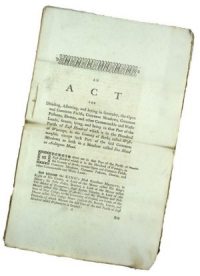
The landowners turned to Parliament for action, and the Acts of Enclosure came into effect on most of the arable land of the country between 1760 and 1820. The Act to enclose the old open fields of Warmington was passed in 1774 and the commissioners drew up the map of awards of land in 1775. Over the course of the next two years the hedges, ditches and roads of the parish were laid out in the pattern that largely remains today.
It is interesting to look at the List of village inhabitants 1777 to see the range of names and professions that existed then in our village.
Enclosure satisfied the larger landowners and farmers because the land eventually became concentrated into fewer hands as many smallholders sold out, and it could be farmed as the holder wished without recourse to the manorial court.
Resentment was felt by the labouring classed who now received only day wages and lost many of their ancient rights, such as grazing their pigs on the common or in the woods. Their situation worsened in the early 19th century yet there seems to have been no mass exodus despite the lure of the industrial centres.
During this period the harvests continued to be poor and the land owners became increasingly worried. In 1804 the first Corn Law was introduced by the powerful landowners who dominated Parliament. They wanted to protect their profits by imposing a duty on imported corn. Farmers feared that when the Napoleonic wars came to an end in 1815, the importation of foreign corn would resume and the price of corn would fall. This fear was justified as the price fell from 126s. 6d. a quarter in 1812 to 65s. 7d. three years later.
Landowners applied pressure on members of the House of Commons to take action to protect the profits of the farmers. Parliament responded by passing a law permitting the import of foreign wheat free of duty only when the domestic price reached 80 shillings per quarter (8 bushels).
There was a dreadful harvest in 1816. This caused bread prices to increase rapidly. This was followed by industrial unrest as workers demanded higher wages in order to pay for the increased food prices. As well as strikes there were food riots all over Britain.
On 15 May 1846 Sir Robert Peel successfully repealed of the Corn Laws against an angry lobby of farmers and landowners. There fears were proved unfounded and the rural economy of the country grew at a fast pace. By 1861 the population of Warmington had more than doubled to 724, peak that would not be reached again until 1961.
During the middle of the 19th century the industrialisation of the country started to have an impact locally. The Peterborough to Northampton railway was opened by the Birmingham and London Railway Company in 1845 at a cost of £429,409. By 1870 Northampton was a centre for boot and shoe manufacturing and farms were employing 20 or more workers.
The population started to move away from the village centre in greater numbers with the development of farmhouses and their associated tenements for the farm workers. Warmington was a thriving village with two carpenters, a wheelwright, a tailor, a shoemaker, a baker, several grocers and butchers, two brewers, four public houses (the Angel, The Hautboy and Fiddle, the Queen Adelaide and the Red Lion), a miller and many trades relating to farming.
1875 to the 21st century
The boom of the mid 19th century ended with the flood of cheap grain from America. The invention of the automatic binder meant the open prairies of mid west America could be farmed without the need of a large workforce. The cheap imports brought a down turn in the farming industry that continued until the start of the First World War. In 1881 the population was down to 622 and in 1891 it had fallen further to 600.
Many farmers went bankrupt or had to sell their land to avoid the debtor's courts. If there was no mass exodus from the village after 1774, there certainly was after 1874. Many names associated with the village for long periods disappear during the late 19th and early 20th centuries. The new farmers put more land to grass relying on livestock to make a living.
There were some attempts to improve the life of farm labourers during the latter part of the 19th century. The High Bailiff of the County Court, Benjamin Taylor was at the forefront of the agricultural trade union movement and was elected President of the Peterborough Union in the mid 1870s. In 1875 he leased 11 acres of land in Warmington for allotments to be used by union members in the village. The labourers of Warmington decided to call their holding Providence Farm and by 1881 there were 188 allotments in use.
World War I left many families without fathers, or sons as 24 solders from the village died in action. The Kidd family, who lived in Eaglethorpe, lost three of their four sons. Post war, the decline in the rural economy continued and was reflected in the decline in the local population. It fell to 550 in 1921 and 517 in 1931.
Some developments continued, in 1920 the War Memorial was erected on the Church lawn and in 1938 the Local Authority built the council houses on Little Green.
World War II also left its mark on the village. In early October 1939, 21 children from London were evacuated to the village with their teacher Mrs Willams. The cricket pitch (where Nene Pastures now stands) was lost to the 'dig for Victory' campaign as Britain tightened its belt. With the village surrounded by fighter bases a dummy airdrome complete with grass airstrip and lights was constructed next to the old A605.

Warmington also had its own Home Guard based in a shed next to the Hauteboy and Fiddle. On 30th June 1942 the headmaster of the village school recorded in the school log book, 'Very slight air raid damage to the roof slates about 2.30am. One bullet hole (machine gun)'. Peter Pearce sent us some personal Recollections of Warmington in the 1940s.
Before the end of the war new developments started. In 1943 the Oundle and Thrapston Rural and District Council built new houses in Church Street (Nos 6 to 12) that were originally called Elderkin Terrace.
The post war era brought dramatic change to Warmington. Street lighting was installed and the population began to grow with the occupation of new housing in Church Street opposite the school (called East Crescent) for returning servicemen. However they could not rely on farming for employment and most people had to travel outside the village for work. This trend continues with people commuting far beyond the county to London and even Europe.
By the mid 1950s new houses were beginning to fill in the gaps along Chapel Street and Buntings Lane. Better travel and the growth of the manufacturing industry also had an effect on the village. Traditional trades and rural industries were no longer economic. In 1958 the miller Mr Haynes retired and Warmington Mill closed, ending over 900 years of industry on the site. In the 1960s the ford on Church Street was replace by a bridge and the fish and chip shop closed and was converted into the Red Lion Pub toilets.
In 1961/62 the Acremead development commenced and during the early to mid 1970s Drapers Close and Pierce Crescent were built. In the 1970 there were still four shops in the village and a garage (opposite the Village Hall) where Laurence Williamson was repairing the growing number of cars in the village.
In the late 1980s the Police house opposite the Red Lion closed and in 1990 the Methodists Chapel was converted to a private home just a few years after celebrating its centenary. In 1992 the new cottages and houses in Chapel Street, opposite the Red Lion were built and the Post Office moved to Glebe Stores when the Maxwell's moved to Hertfordshire. 1996 saw the opening of the by-pass and for the first time in many years Eaglethorpe became an integral part of the village again. The two Pocket Parks were opened in 1998 and the biggest development in the village, Nene Pastures, took place between 1999 to 2001.