This is a part of a drawing of the village by Chris Ellard, produced for the millennium celebrations, which now forms the centre of the village Interpretation Panel in Church Lane. It shows a few of the many places of interest in the village.

Overview
Warmington can trace its origins back to the 7th century when the King of Mercia granted the land to the Abbey of Peterborough. A charter of Edgar in 963 also names Warmington among the estates of the monks of the Abbey of Peterborough. Warmington is listed in the Doomsday Book as a part of the land of Peterborough Abbey. It is described as having 71/2 hides. Land for 16 ploughes. A mill, 40 acres of meadow and 1 acre of woodland. There were also 13 villagers, three freemen and two small holdings.
The village is also located on the route of a Roman Road running from Elton to Barnwell.
- The Fern is an area of woodland named on a 17th century map of the area. It runs alongside the west side of the footpath from Warmington to Elton.
- The Dovecote is of mixed age. The lower part dates from the 14 or 15th century. The top was rebuilt in the 16th or 17th century. Further rebuilding took place around 200 years ago. It contained 797 wooden nesting boxes and a rotating frame to give access to the nests. It is located in Eaglethorpe on the Northwest edge of the village.
- The Methodist Chapel was built in 1881. It is now a private home.
- The Red Lion Pub dates from the early 1800s. The toilet block was once the village fish and chip shop.
- The Manor House dates from 16th and early 17th century and was built by the Elmes family.
- The Church of St Marys is 12th century and considered to be one of the best examples of a rural parochial church of this
style and period. - Taylors Green runs along the southern edge of the village. Immediately to the south of the road was the hamlet of Southorpe. The hamlet is shown on an enclosure map of 1775 but not on a latter map of 1889.
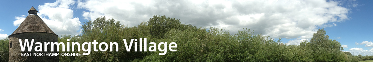
- Other places of interest in the village include, the Oast House, The Mill, the moat, the water meadows, protected wild flower verges, a WW2 pill box and the two Pocket Parks.
The Church of St Mary the Virgin
 The Church of St Mary the Virgin, Warmington, was described by the Royal Commission on Historical Monuments in their inventory of 1984 as: '...an outstanding building of the late twelfth and early 13th century....'.
The church is very uniform in style having been built over a relatively short period between 1180/90 and 1280. The architecture and general style of the church has been uneffected by the restoration work that has taken place over the past 700 years.
The early history of the church is unknown, however, there is evidence that the church is built on the site of a smaller and older church dating from before 963. The only visible indications remaining are the column plinths either side of the Nave, which have elaborately carved mouldings. In the Taxatio Ecclesiastica of 1291/92, Warmington church was valued at three times that of any other local church.
The church was restored in 1850 when an 18th century gallery on the West side was removed. Evidence for its existence can still be seen on either side of the tower clock face where there is a weather course of a low pitched roof. There are also grooves in the tower buttresses where they were crossed by the roof structure. Further restoration was undertaken in 1875/76 by the last Lord Carysfort and architect Sir Gilbert Scott. This included the rebuilding of the south porch, the addition of the vestry and organ chamber and the replacement of the plastered roof in the chancel by trussed rafters.
St Mary's is a fine example of a quintessential English village church. It has been a symbol of stability at the centre of Warmington for over 800 years. Today it remains the focal point of the village, a centre for worship and cultural events.
functions. Responsibility for the fabric of the church also became divided. The parish being responsible for the nave and the rector responsible for the chancel.
The original building comprised part of the current Nave and a small Chancel. The south aisle was added first, then the north aisle. The south aisle and nave were then extended by two bays followed by a similar extension of the north aisle. The lower half of the west tower was added around 1230 along with the south porch.
At the end of the 13th century the rebuilding of the Chancel was commenced. The new Chancel was built around the existing building and is therefor wider than the Nave, and slightly defected to the north. Around this time the north aisle was also widened and two new windows inserted in the external wall.
Various minor changes and additions were made during the early 14th century and some rebuilding took place in the 15th century. In the 16th century several buttresses were added to reinforce the walls to the Chancel which had started to lean outwards. Other than the addition of the vestry in 1875/76 the church remains much as it was in the 13th century.
The church is constructed from Barnac ragstone with ashlar and Barnac stone dressings in several places. The roof in the Nave dates from the 13th century and is one of the most impressive features of the church. Although it is constructed in timber it is a simulation of stone built barrel vaulting. This style is commonly found in cathedrals such as York Minster and monastic churches. It is rare to find a ceiling of this style in a village church.
Down the centre of the roof are nine bosses carved with face of the Green Man. This image is commonly found in Northamptonshire churches, it is a pagan representation of the spirit of nature. The church has one of the finest collections of Green Men carvings in England.
The north aisle roof has a boss carved with the date ANO DOM 1650 and a second boss with the initials RBIM. Whom RBIM was is unknown. Eight of the wooden corbels on the north side of the roof timbers are carved with human heads. The south aisle roof dates from between the 15th and early 16th century. The south aisle also has four of the original stone corbels, all carved with human masks.

The red labels on the plan refer to some of the points of interest in the church.
The Old Methodist Chapel
The Old Methodist Chapel, now a private home.
 The first Wesleyan Chapel in Warmington was built in Church Street in 1808 at a cost of £150. The property is now two dwellings. The first Methodist Minister was appointed in 1827 and the first baptism conducted was of Eliza, daughter of Valentine and Elizabeth Brudenell by the Rev J Brown on 19 July 1840. The land for the current Chapel, now a private home, was purchased in 1878 for £75 from John Thomas Whitehead of Blaby. The current building, completed in 1881, is constructed from Warmington red bricks that were kilned in the village. The building has been described as a good example of late 19th century simplicity. There were 15 founding fathers, four of which lived in Warmington; Samual Hayes, James Hayes, William Wade and William Martin. In 1883, George Baker purchased and installed a pedal tracker organ from Lowick Church that had been built in 1865 by Forster and Andrews of Hull.
Up to 1942 the Chapel operated a system of 'Seats Rent'. A family would reserve a seat in the Chapel by paying annual rent. It was used as a method of raising funds for the upkeep of the Chapel. In 1906 fourteen families rented 45 seats at a total annual cost of £2 and 5 shillings.
The Dovecote
 Dovecotes are thought to have been introduced into Britain by the Romans. The pigeons could have eight or ten broods a year and provided a valuable source of fresh meat, particularly during the winter months. The Warmington Dovecote is of mixed heritage. The lower section, constructed from large square dressed stone, dates from 14th or 15th century when dovecotes we typically circular in style. The upper part is considered to be a late 16th century reconstruction using mix of stone rubble and larger square stones similar to those of the base. Further rebuilding of the top of the Dovecote is thought to have taken place in the 19th century. The roof is Colleyweston slate with a central octagonal lantern that provides access for the birds. The 797 nest boxes are rather unique. They are constructed from a wood and lath frame covered with mortar. The current nest boxes are early 1980s reconstructions. Access to the nest boxes was via a ladder revolving around a central post called a Potence.
Pocket Parks
The idea of the Poket Part started in Northamptonshire and Warmington was the first village to simultaneously set up two Pocket Parks.
Across East Northants there are 15 Pocket Parks covering a wide range of habitats. Many are supported by the County and District councils, the
These are a small green space managed by the local community to create and preserve features indigenous to the local area. They also provide an environment everyone can enjoy and an educational facility for local school children. By making regular visit to the Pocket Parks children can complete the Explorers Scoresheet and receive a Pocket park badge and Explorers certificate.
Countryside Agency, Parish and Town councils and Rural Action. The location of the Warmington Pocket Parks, in Big Green and Eaglethorpe are well signposted and marked on the village street map. Northamptonshire Council also have a web site with general information on Pocket Parks, special events and details of over 70 in the county. To visit the site click here.
Cherry Plum Tree Walk, Old Orchard Pocket Park The hedge provided protection for the apple trees and cover for the farm animals left to graze the orchard.
The Old Orchard Pocket Park in Eaglethorpe is the largest of the two, covering nearly half an acre. Part of the orchard that adjoined the Mill House was lost when the Warmington bypass was constructed. The County Council agreed to lease the remaining orchard to the Parish Council for 21 years. The park serves to protect and nurture an increasingly rare orchard and introduce English apple varieties that are facing extinction, including Barnack Beauty and Lord Burghley. On the northern boundary of the park a hedge row of mixed Northamptonshire species has been planted and the grassed areas managed as meadow land to increase biodiversity. The park includes a cherry plum tree walk, picnic area and seating. In early October there is an Apple Day celebration in the park, with various attractions and refreshments. Among the wildlife found within the park are Burnet, Saxifrage, Lady's Bed Straw and Bird's-Foot Trefoil.

Warmington's second Pocket Park in located in Big Green between houses number 14 and 20. Although less than a third of an acre, the park includes a pond, bog garden, an indigenous hedge row, wild flower meadow and a living willow igloo designed by the late Geoff Hamilton. The area was used as allotments but fell into diss-use and neglect. The District Council had considered building on the site, but agreed to lease the land to the Parish Council for 25 years. The park has strong links with the past as Big Green is thought to be the original site of the village common. Untill a few years ago the field beyond Big Green had clear evidence of ridge and furrows indicating this was once the location for some of the villagers 'furlongs' in medieval times. Little Green to the west was the village green and measured some 230 yards (east - west) by 100 yards (north - south). Among the wildlife to be found in the Big Green Pocket Park are the Brown Argus Butterfly, Frogs and Toads, pond plants from the Ashton Dragonfly Museum, Horse-radish and Elm trees. The Pocket Parks are managed by the Warmington Pocket Parks Committee. For more information and offers of help to maintain the parks, please contact Katy Stewart.
Guides to both Pocket Parks are available from the Warmington Post Office.
The Oast House
Can anyone provide us with more information on this house? Please let us know via the Contact Us page
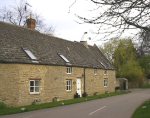
Warmington Mill
 For over a thousand years the Nene valley has been the location of much farming activity particularly the growing of corn and wheat. During medieval times the area was the bread basket of England. The land either side of the river is rich and fertile and the river provided the power required to drive the many water mills located along its length. Locally there are water mills at Barnwell (now a public house), Cotterstock (now private homes), Eaglethorpe and Elton. The mill at Warmington is recorded in the Doomsday Book.
The prosperity of the area during medieval times also supported a number of windmills. Excavations of a small clay mound near the Tansor cross roads in 1995 found the slots of the foundations of a post mill. It is believed the mill was only used for a few decades in the mid 13th century. The lack of timber impressions seem to indicate the mill had been dismantle rather than left to decay. Warmington mill is located in the Hamlet of Eaglethorpe. On early maps the area is called Mill End. The present mill building is thought to vary in date from the 19th century (the northern half) to the early 1900s. It is constructed from stone, comprises three floors and included two water wheels and millstones. This twin water wheel arrangement is clearly shown on the parish survey plan of 1621.
In an architectural survey of the village conducted in 1937, J W Bloe states,'There is a wheel to the northern mill-race and the remains of one to the southern, while south of each are the hexagonal drums or casings for the grinding machinery, the southern derelict'. The single mill stone continued in operation untill 1958 when the miller, Matthew Hayes retired. He is also noted as the occupier of the mill in J W Bloe's survey of 1937. For many years part of the mill used as a store by the Elton Boat Club which is based on the mill stream. In the late 1990s a fire destroyed the roof and much of the timber work in the building.
Today the mill has been converted into a retail outlet for a ceramic tile company. Much of the work has been carried out in a sensitive manner, although the new fire escape under the hoist loft spoils the clean, uncluttered lines of the building. To the north of the mill is Thistle Home Meadow. A water meadow that lies between the mill stream and the main course of the river Nene. Other than summer grazing by cattle, this area has remained unaltered for hundreds of years and is a haven for wildlife and plants.