Detailed Cycle Map We are so fortunate in our village to be able to walk out of our homes and go on so many lovely country walks without ever needing to get in a car. There are many dog walkers and runners in the village who know all the local walking routes well. The walk starting at The Mill (to the north of the A605, accessible via the underpass at Eaglethorpe) across to Fotheringhay is renowned and enjoyed by many locals and tourists for its lovely views across the fields.
A village family worked with the parish council to develop a series of lovely walks around the parish and from this the RAINBOW WALKS project was born. You can find this by clicking on the following link: https://www.smartmovenorthamptonshire.net/sites/default/files/2017-12/Short%20Walk%20Map%20-%20Warmington%20Rainbow%20Walks.pdf
So get walking, it's good for the body and for the soul!
Walks and Cycle Routes Local to Warmington.
This is a fabulous resource for local walks: https://www.smartmovenorthamptonshire.net/east-northamptonshire-leisure-walks
Local walks and cycleways below have been kindly shared with us by Robin Moore. These routes have been designed and tried out by Robin who hopes others like him will get out and about and enjoy the lovely local countryside which is right on our doorstep! Do try some out and maybe you could send us some photos for the website. A huge thank you to Robin and his generosity in letting us use these routes on our village website!
Robin has been raising tremendous amounts of money over the last twenty years for charities by getting sponsorship for his walks in and around the British Isles and abroad. If you would like to find out more about Robin and his charity fund raising vsit his page https://www.facebook.com/WalkingForCharity/
Do give these walks/cycle rides a try and let us know how you get on!
THE OUNDLE PILGRIMAGE CYCLE ROUTE
Raising funds for Sue Ryder Care.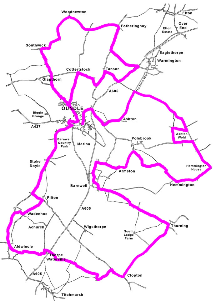
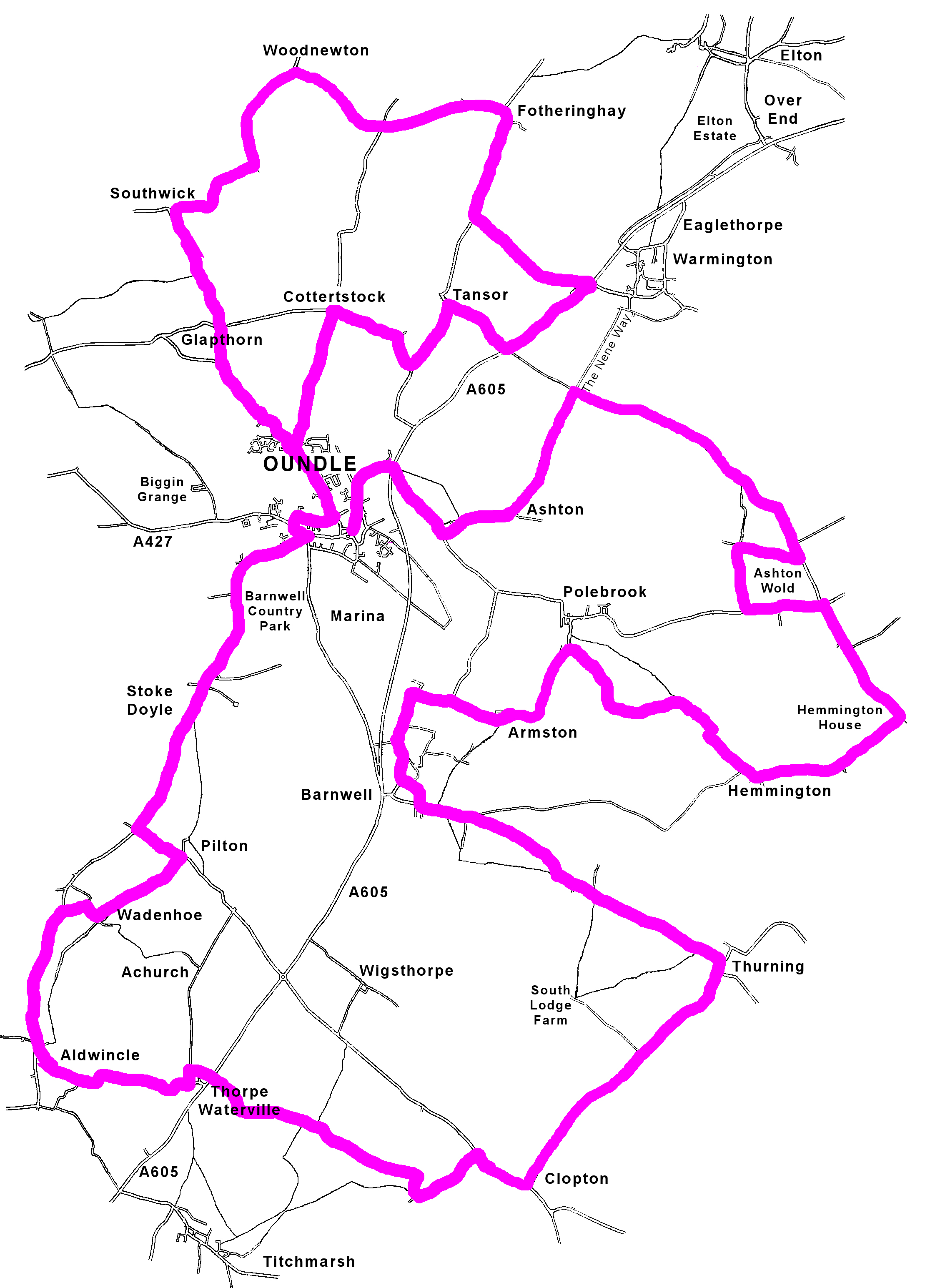
THE ROUTE: Marked with scallop shells and red/yellow taped sign posts, the 40 -mile journey is initiated at St Peter's Church and leaves Oundle via the bypass roundabout at the Ashton Junction.
This version of the Pilgrimage (modified from the original walking guide), enables cyclists to follow the main route using country lanes and roads in lieu of bridleways and footpaths. The information below, in addition to our Pilgrim Guide, should clarify the alternative road sections required to complete the journey. An experienced cyclist could complete the distance in a day, though the Pilgrimage is designed to be enjoyed for its rural pleasantness rather than as an endurance test.
PLACES OF INTEREST: The Oundle Heritage Trail (available from the Tourist Centre) highlights all the town's prominent landmarks. Locations en route include: Polebrook Aerodrome Memorial; The Chancel of All Saints Church, Barnwell; Wadenhoe Mill/Church; Pilton Church; Fotheringhay Church & Historical Mound;
EQUIPMENT: A Pilgrim Passport (to collect stamps - see main guide). Food and water are essential; waterproofs and basic First Aid kit are advised. Please contact Trek-Kits for further information about specialist equipment.
PHASE 1: OUNDLE TO BARNWELL - 12 miles.
After collecting a stamp from either St Peter's Church or the Rose & Crown, which is Pilgrim HQ and breakfast venue, cyclists can get underway after 8am if required. From the market square, follow the thoroughfare along North Street to the A605 roundabout. Taking the byway to Ashton, pass the derelict mill on the right and enter the village a short distance ahead on the left. Both mill and village were converted by the Rothschild Family at the start of the 19th century when Ashton was little more than a farm. Since then it has risen to fame through The World Conker Championship which is still held locally each year in October. At the centre of the village is an inn called The Chequered Skipper, derived from a woodland butterfly which sadly no longer frequents the estate. The pub green is an idyllic location to relax with a beverage amid the surroundings of chestnut trees and the reed-thatch cottages that accentuate Ashton's quirky charm. Continuing the journey to the end of the village, the Nene Way turns left at Ashton Wold. The solid track is partially encompassed by woodlands, eventually opening up into farmland as it crosses the estate to Elmington Ranges. From here a dirt track descends to the Polebrook Aerodrome Road: on reaching the junction, turn right and follow the yellow signs to Hemmington.
The first 2 miles of this section skirts the rural boundaries and escarpment of Ashton Estate as far as the Polebrook / Lutton Junction. The wooded areas are abundant with wildlife as the cheerful voice of nature displaces the relentless drone of the now-distant A605.
After crossing carefully at the junction, continue along the Hemmington Road which passes the 351st BG (H) 8th Air Force Memorial Monument a mile or so on. The redundant airfield is now little more than a nature reserve, though the plaque stands as a tribute to a special friendship forged by two nations in the theatre of war. Leaving this point, the road narrows as it winds through the countryside to Hemmington. Set back from the centre of Hemmington is the 14th century church of St Peter and St Paul: much of which was rebuilt by Lord Montagu in 1666. Beyond the village is a chicken farm where the main Pilgrimage bears right, traversing the agriculture on a diagonal course to Polebrook. To reach this destination, continue along the road for another 2 miles following the markers to the church and inn. Polebrook's church of All Saints is known throughout the kingdom for its sleeping Gargoyles and one-handed 17th-century clock. A little further on is the King's Arms which is the epitome of an olde worlde inn, built in stone with interior of beams and open fire place. The pub has become a popular dining venue in recent years and is noted for its real ales too which include local brews by Digby of Barnwell.
Leaving Polebrook along the Oundle Road, turn left at the Armston Crossroads and continue along the byway to Barnwell. The next 2 miles give a glimpse of Armston Manor poking through the woods on the left and later the Royal Castle which stands at the foot of Barnwell village. The castle has weathered through the passage of time, though the manor has retained much of its dignity and baronial influence. For many years it belonged to the Montagu Family, and in the last century was the country seat of the Duke and Duchess of Gloucester.
Continuing beside the brook as far as the medieval stone bridge, one now has the opportunity to visit St Andrew's Church or even the chancel of Barnwell All Saints which holds memorials to The Montagu Family. Another intriguing place is The Montagu Arms - an idyllic, unspoilt pub, endowed with a rustic charm that uniquely captures the semblance of its medieval past. It also has a colourful beer garden and large restaurant, which on Pilgrimage Weekend serves food all day until 9pm!
PHASE 2: BARNWELL TO WADENHOE - 12/14 miles.
Beyond the pub car park (opposite Berridges Farm), follow the road to Thurning Village (3 miles).
Over the Pilgrimage Weekend it will be possible to collect an original "Camino de Santiago Stamp" from the church of St James; St James is the Pilgrim Saint and the Cathedral at Santiago in Spain remains a tribute to him serving as a spiritual icon to travellers worldwide. Thurning Village Hall will also be accessible to those who require water/toilets. If the attendant, (Mrs Cap lives opposite the church) isn't present the stamp will be left by the entrance: so please use it to authenticate your stop at the village. Resuming the journey, follow the signs to Clopton which is 2.5 miles; then cycle a further 3 miles along the Roman Road to Titchmarsh.
Leaving Clopton Village, it is possible to bypass Titchmarsh by using an alternative route to Thorpe Waterville; this cuts out an unwelcome section along the A605. The trail adopts a permissive farm track accessible from a gate on the right of the road which is just a few metres beyond the Titchmarsh footpath/pilgrimage sign. The track passes a solitary barn (visible from the road), and follows a course across 2 miles of agriculture. This route is marked by yellow arrows/scallop shells and concludes at The Fox Inn at Thorpe Waterville; cross carefully to the pub (ask for a passport signature if required), and then follow the taped signs along the back roads via Thorpe to Aldwincle (2 miles).
Those participants staying on the main route continue to Titchmarsh (3 miles) and collect stamps/signatures from either one of two inns which are usually open all day. Leaving Titchmarsh, the imposing 15th century church dedicated to St Mary the Virgin lies at the foot of the village, and a few metres on cyclists will need to cross the A605. While the Pilgrim Walkers make their way across Titchmarsh Nature Reserve, cyclists brave the downhill section to Thorpe (and then Aldwincle).
At Aldwincle there is a tearoom called Pear Tree Farm which also provides camping and B&B facilities. After cycling a further mile, turn right into Wadenhoe where along Church Street you will find the quintessential King's Head, a 17th century pub set in an enviable riverside location. A short distance from the inn, standing isolated on a hill above the Nene Way, is the parish church dedicated to St Michael and All Angels. The church dates from the 13th century and today serves a population of about 100. It is a peaceful location, affording a banquet of colourful scenery amid the distant sound of waters breaking beneath the mill.
PHASE 3: WADENHOE TO FOTHERINGHAY - 12 miles.
Backtracking to the top of Church Street, turn left and then a few metres on, bear right to follow the byway to Pilton Church (2miles). The diminutive little road is pleasantly rural capturing the quiet simplicity of the Nene as it meanders towards Lilford Bridge. There is little to see at Pilton other than the delightful church which stands in a meadow by the Manor House, reached from a track at the end of the village. Resuming the journey from the foot of the village, turn right and cycle half a mile to the Stoke Doyle Road. Turning right again at the junction, continue to Stoke Doyle (2 miles) where the award winning church gardens are well worth a visit. You will also pass The Shuckburgh Arms where opening times may vary; so please check the food time table and afternoon hours.
Setting off from the village allows a clear view of St Peter's soaring spire which announces completion on the first part of the journey.
After passing the cemetery on Stoke Doyle Road, bear left onto Benefield Road by the Catholic Church; then a hundred meters on (near the Drill Hall), turn right onto Milton Road. The lane skirts the stone-walled Oundle Town Cricket Club and passes the School's opulent chapel on its way to Glapthorn Road. Turning left at the junction, cycle half a mile to The George Inn - an old pub which has been nicely modernised with bar, lounge and restaurant. The cycle route is marked on the road signs outside the inn, indicating 2 miles to Southwick which sits on the edge of Rockingham Forest. There is a lovely woodland section descending from the Southwick Water Tower to the 16th century Shuckburgh Arms which is one of the oldest pubs on the Pilgrimage Trail; the proprietor, David Dixon caters for hikers/cyclists who require takeaway picnic lunches on Pilgrim Days and may host folk music entertainment on those evenings. Participants wishing to prolong their stay at this characterful little place should phone David about overnight camping/breakfast facilities during our fundraising weekend. Opposite the pub is the parish church, originated by the Knyvett Family in the 13th century; the churchyard was built on land formerly quarried by the Romans for ironstone which has been predominant in Northamptonshire buildings ever since.
Turning right, away from the church and Southwick Hall, the Pilgrimage adopts the Fotheringhay Road as its route for the next 3 miles. It is little more than a farm road, exposing participants to a quiet countryside comprised of pastures, crops and paddocks interspersed with ancient woodlands and coppices. Soon the strawberry fields emerge with the distant view of the church as the journey culminates at the historic thatched village of Fotheringhay and its superlative Falcon Inn. This sumptuous establishment is known throughout the kingdom for its award-winning cuisine and traditional beers. It consists of a restaurant, beer garden; lounge bar and an old-fashion tap room which immediately evokes the Elizabethan era. The village has gained much prestige from the ecclesiastical wonder of its cathedral-style church, opulent medieval buildings and the eventful past of its Royal visitors which have made it a location of national importance. The former Fotheringhay Castle was the birthplace of Richard 111 while the less fortunate Mary Queen of Scots was imprisoned there and ultimately executed in 1587.
PHASE 4: FOTHERINGHAY TO OUNDLE - 5 miles/8 miles.
The cycle route follows part of the original Oundle Pilgrimage and a byway to Elton (there is also a link route from the Nene Valley Railway). Those taking this route (4 miles) can obtain a stamp from the Crown Inn by the green, or the Black Horse/ All Saints Church at the top of village. From here it is possible to ride through Elton, cross the bypass and follow the cycle route through the estate to the old Warmington Road (2.5 miles); however we recommend a safer route from Fotheringhay to Warmington along the Tansor Road via the "Bunny Run" (4 miles).
Avoiding the complications of the bypass, one can collect a stamp from the Falcon in lieu of Elton and continue along the Tansor Road. Using this route, turn right at the end of the village and cycle towards the Nene Bridge. Crossing the 18th century bridge allows clear views of the iconic castle mound on the left above the river; while to the right the landscape is dominated by the unsurpassing grandeur of The Blessed Virgin Mary and All Saints Church, which resonates something beyond beautiful. Continue a mile to the next junction ("the Bunny Run") and turn left towards Warmington village (2 miles). Cross carefully at the roundabout and take the cycle path to Eaglethorpe (on the left) where you will find the Red Lion Inn. The lovely inn, mill and church make Warmington an authentic village location which is no longer hostage to the busy main road. In addition to serving popular real ales and European Lagers, the pub has built up an excellent food trade; it also has beer garden and a marquee for hosting social events. Continuing the journey through the village, the Nene Way reveals a few shops, social club and the 12th century St Mary the Virgin Church, conceived largely through the wealth of its agriculture. After crossing from Church Street to Spinney Close, the Nene Way descends to Taylor's Green and continues to a farmyard on the right. Turning left at the farmyard the Nene Way follows a Roman track beyond Tansor Grange to the Polebrook Aerodrome Road. At this junction there are 3 choices of route back to Oundle: the first option revisits Ashton Estate along the present course of the Nene Way (used in phase 1); for alternative routes to Oundle turn right and cycle to the A605 where you can join the cycle route at Tansor Crossroads. At the main road you can either turn left and continue into Oundle via Elmington; or cross to Tansor, using the island on the right. From Tansor follow the blue markers along the quieter lanes which we use in our family walking guide. Both cycle routes terminate at Station Road Bridge though it is possible to omit the A605 completely by extending your journey to Cotterstock; then a further 2 miles to the George Inn, Oundle.
We hope your day has been an enjoyable one, leaving fond memories of enchanting villages with medieval churches and olde worlde inns that have made the Nene Valley an appealing place to visit.
Please feel welcome to join us at the Rose & Crown where the pilgrimage celebration includes a subsidised weekend beer festival, music and Sunday Banquet.
CAR PARK FACILITIES
Joan Strong Centre, East Road, Oundle. Trek-Kits, Eastwood Estate, Oundle. The Drill Hall, Benefield Road, Oundle.
ACCOMMODATION
The Ship Inn, 18 West Street, Oundle.
REGISTRATION
Contact Trek Kits to register for your pilgrimage event, purchase guides and receive advice about equipment.